


KASG - Springdale Muni
Located in Springdale, United States
ICAO - ASG, IATA - SPZ
Data provided by AirmateGeneral information
Coordinates: N36°10'35" W94°7'9"
Elevation is 1352 feet MSL.
Magnetic variation is 04° East View others Airports in Arkansas
Operational data
Special qualification required
Current time UTC:
Current local time:
Weather
METAR: KASG 051853Z 32003KT 2 1/2SM BR FEW006 FEW018 FEW043 17/17 A2999
Communications frequencies: [VIEW]
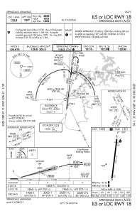
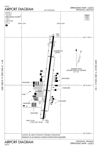
Runways:
| RWY identifier | QFU | Length (ft) | Width (ft) | Surface | LDA (ft) |
| 18 | 187° | 5302 | 76 | ASPH | |
| 36 | 7° | 5302 | 76 | ASPH |
Airport contact information
Address: Springdale United States
