


KALN - St Louis Rgnl
Located in Alton/St Louis, United States
ICAO - ALN, IATA - ALN
Data provided by AirmateGeneral information
Coordinates: N38°53'24" W90°2'46"
Elevation is 543 feet MSL.
Magnetic variation is -01° East View others Airports in Illinois
Operational data
Special qualification required
Current time UTC:
Current local time:
Weather
METAR: KALN 290915Z AUTO 00000KT 5SM +RA SCT013 BKN075 OVC090 14/14 A2987 RMK AO2 LTG DSNT NE THRU SE P0007 T01400138
Communications frequencies: [VIEW]
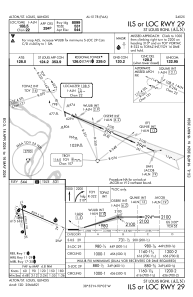
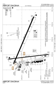
Runways:
| RWY identifier | QFU | Length (ft) | Width (ft) | Surface | LDA (ft) |
| 11 | 113° | 8099 | 150 | ASPH | 8099 |
| 29 | 293° | 8099 | 150 | ASPH | 8099 |
| 17 | 173° | 6500 | 100 | ASPH | |
| 35 | 353° | 6500 | 100 | ASPH |
Airport contact information
Address: Alton/St Louis United States
