


KALI - Alice Intl
Located in Alice, United States
ICAO - ALI, IATA - ALI
Data provided by AirmateGeneral information
Coordinates: N27°44'27" W98°1'37"
Elevation is 178 feet MSL.
Magnetic variation is 06° East View others Airports in Texas
Operational data
Special qualification required
Current time UTC:
Current local time:
Weather
METAR: KALI 012153Z AUTO 12015G24KT BKN070 30/23 A2967 RMK AO2 PK WND 12028/2118 SLP043 T03000233 $
TAF: KALI 012209Z 0122/0218 14014G23KT P6SM VCTS SCT020CB OVC045 TEMPO 0123/0203 3SM TSRA BKN020CB FM020300 13012KT P6SM BKN010 FM021100 12008KT 4SM BR OVC012 FM021400 14010KT P6SM BKN020
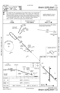
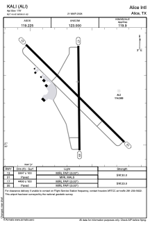
Communications frequencies: [VIEW]
Runways:
| RWY identifier | QFU | Length (ft) | Width (ft) | Surface | LDA (ft) |
| 13 | 134° | 5997 | 100 | ASPH | |
| 31 | 314° | 5997 | 100 | ASPH | |
| 17 | 179° | 4490 | 100 | ASPH | |
| 35 | 359° | 4490 | 100 | ASPH |
Airport contact information
Address: Alice United States