


KALB - Albany Intl
Located in Albany, United States
ICAO - ALB, IATA - ALB
Data provided by AirmateGeneral information
Coordinates: N42°44'57" W73°48'7"
Elevation is 284 feet MSL.
Magnetic variation is -13° East View others Airports in New York
Operational data
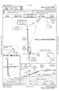
Special qualification required
Current time UTC:
Current local time:
Weather
METAR: KALB 300351Z 01005KT 10SM FEW060 SCT080 BKN120 12/05 A3003 RMK AO2 SLP168 T01220050
TAF: KALB 292341Z 3000/3024 35005KT P6SM FEW045 BKN250 TEMPO 3003/3006 4SM -SHRA BR BKN025 OVC040 FM300600 05005KT 3SM -SHRA BR SCT008 OVC025 FM301200 14006KT 5SM BR VCSH BKN008 OVC020 FM301600 15008KT P6SM OVC025 FM302000 16012G18KT P6SM BKN030 PROB30 3020/3024 3SM -TSRA BR BKN015CB
Communications frequencies: [VIEW]
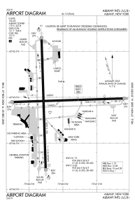
Runways:
| RWY identifier | QFU | Length (ft) | Width (ft) | Surface | LDA (ft) |
| 01 | 358° | 8500 | 150 | ASPH | 8500 |
| 19 | 178° | 8500 | 150 | ASPH | 8500 |
| 10 | 88° | 7200 | 150 | ASPH | 6780 |
| 28 | 268° | 7200 | 150 | ASPH | 6007 |
Airport contact information
Address: Albany United States
