


KAIZ - Lee C Fine Meml
Located in Kaiser/Lake Ozark, United States
ICAO - AIZ, IATA - AIZ
Data provided by AirmateGeneral information
Coordinates: N38°5'46" W92°32'58"
Elevation is 868 feet MSL.
Magnetic variation is 00° East View others Airports in Missouri
Operational data
Special qualification required
Current time UTC:
Current local time:
Weather
METAR: KAIZ 071956Z AUTO 24011G16KT 10SM SCT070 27/13 A2959 RMK AO2 SLP013 T02720133 PNO $
Communications frequencies: [VIEW]
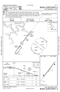
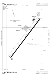
Runways:
| RWY identifier | QFU | Length (ft) | Width (ft) | Surface | LDA (ft) |
| 04 | 37° | 6497 | 100 | ASPH | |
| 22 | 217° | 6497 | 100 | ASPH |
Airport contact information
Address: Kaiser/Lake Ozark United States