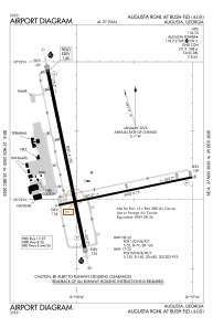


KAGS - Augusta Rgnl At Bush Fld
Located in Augusta, United States
ICAO - AGS, IATA - AGS
Data provided by AirmateGeneral information
Coordinates: N33°22'12" W81°57'52"
Elevation is 145 feet MSL.
Magnetic variation is -04° East View others Airports in Georgia
Operational data
Special qualification required
Current time UTC:
Current local time:
Weather
METAR: KAGS 030253Z 13004KT 10SM CLR 21/18 A2997 RMK AO2 SLP147 T02110178 51013
TAF: KAGS 030257Z 0303/0324 16006KT P6SM SCT070 FM030700 00000KT P6SM SCT005 BKN050 FM030900 00000KT 3SM BR SCT005 BKN050 FM031000 00000KT 1SM BR BKN003 FM031300 15004KT P6SM SCT015 BKN200 FM031500 17006KT P6SM SCT050
Communications frequencies: [VIEW]
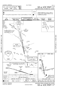
Runways:
| RWY identifier | QFU | Length (ft) | Width (ft) | Surface | LDA (ft) |
| 08 | 78° | 6002 | 75 | ASPH | |
| 26 | 258° | 6002 | 75 | ASPH | |
| 17 | 168° | 8001 | 150 | CONC | |
| 35 | 348° | 8001 | 150 | CONC |
Airport contact information
Address: Augusta United States
