


KAEG - Double Eagle Ii
Located in Albuquerque, United States
ICAO - AEG, IATA -
Data provided by AirmateGeneral information
Coordinates: N35°8'42" W106°47'43"
Elevation is 5837 feet MSL.
Magnetic variation is 11° East View others Airports in New Mexico
Operational data
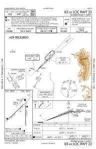
Special qualification required
Current time UTC:
Current local time:
Weather
TAF: KAEG 282320Z 2900/2924 29014G24KT P6SM BKN080 FM290300 30008KT P6SM SKC FM291800 27009G16KT P6SM SKC
Communications frequencies: [VIEW]
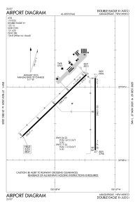
Runways:
| RWY identifier | QFU | Length (ft) | Width (ft) | Surface | LDA (ft) |
| 04 | 46° | 7398 | 100 | ASPH | |
| 22 | 226° | 7398 | 100 | ASPH | |
| 17 | 180° | 5983 | 100 | ASPH | |
| 35 | 360° | 5983 | 100 | ASPH |
Airport contact information
Address: Albuquerque United States

