


KACY - Atlantic City Intl
Located in Atlantic City, United States
ICAO - ACY, IATA - ACY
Data provided by AirmateGeneral information
Coordinates: N39°27'27" W74°34'38"
Elevation is 74 feet MSL.
Magnetic variation is -10° East View others Airports in New Jersey
Operational data
Special qualification required
Current time UTC:
Current local time:
Weather
METAR: KACY 032054Z 08011KT 10SM OVC011 11/08 A3019 RMK AO2 SLP221 T01110078 58005
TAF: KACY 031739Z 0318/0418 08015G23KT P6SM OVC010 FM032100 08010KT P6SM BKN010 FM040600 09005KT P6SM BKN008 FM041500 08010KT P6SM BKN010
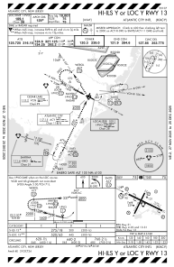
Communications frequencies: [VIEW]
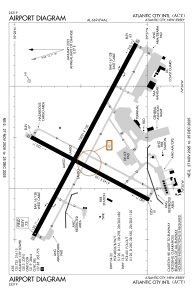
Runways:
| RWY identifier | QFU | Length (ft) | Width (ft) | Surface | LDA (ft) |
| 04 | 28° | 6144 | 150 | OTHER | 6144 |
| 22 | 208° | 6144 | 150 | OTHER | 6144 |
| 13 | 118° | 10000 | 150 | ASPH | 10000 |
| 31 | 298° | 10000 | 150 | ASPH | 10000 |
| H1 | 0° | 0 | 0 | UNK |
Airport contact information
Address: Atlantic City United States