


KABE - Lehigh Valley Intl
Located in Allentown, United States
ICAO - ABE, IATA - ABE
Data provided by AirmateGeneral information
Coordinates: N40°39'9" W75°26'25"
Elevation is 393 feet MSL.
Magnetic variation is -12° East View others Airports in Pennsylvania
Operational data
Special qualification required
Current time UTC:
Current local time:
Weather
TAF: KABE 281720Z 2818/2918 24009KT P6SM SCT040 SCT250 FM282300 25006KT P6SM VCSH SCT060 BKN120 FM290800 29004KT P6SM SCT150 FM291500 29007KT P6SM FEW035
Communications frequencies: [VIEW]
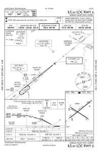
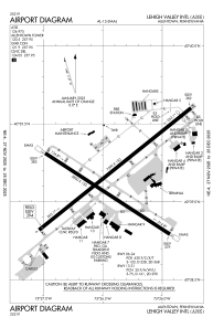
Runways:
| RWY identifier | QFU | Length (ft) | Width (ft) | Surface | LDA (ft) |
| 06 | 51° | 7599 | 150 | ASPH | 7599 |
| 24 | 231° | 7599 | 150 | ASPH | 7089 |
| 13 | 123° | 5800 | 150 | ASPH | 5800 |
| 31 | 303° | 5800 | 150 | ASPH | 5800 |
Airport contact information
Address: Allentown United States
