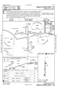
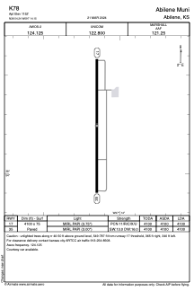


K78 - Abilene Muni
Located in Abilene, United States
ICAO - K78, IATA -
Data provided by AirmateGeneral information
Coordinates: N38°54'15" W97°14'9"
Elevation is 1152 feet MSL.
Magnetic variation is 07° East View others Airports in Kansas
Operational data
Special qualification required
Current time UTC:
Current local time:
Weather at : KSLN - Salina Rgnl ( 38 km )
METAR: KSLN 072053Z 25018G28KT 10SM CLR 27/M03 A2951 RMK AO2 PK WND 25031/2033 WSHFT 2032 SLP986 T02721028 56007
TAF: KSLN 071724Z 0718/0818 22015G22KT P6SM SCT250 FM080000 17008KT P6SM BKN200 FM080200 10008KT P6SM BKN200 FM080600 03010KT P6SM BKN200 FM081200 32012KT P6SM SCT200
Communications frequencies: [VIEW]
Runways:
| RWY identifier | QFU | Length (ft) | Width (ft) | Surface | LDA (ft) |
| 17 | 180° | 4100 | 75 | CONC | 4100 |
| 35 | 0° | 4100 | 75 | CONC | 4100 |
Airport contact information
Address: Abilene United States
