


HLWG - Al Wigh
Located in , Libyan Arab Jamahiriya
ICAO - , IATA -
Data provided by AirmateGeneral information
Coordinates: N24°12'5" E14°41'53"
Elevation is 1558 feet MSL.
Magnetic variation is 3° East View others Airports in Murzuq District
Operational data
Special qualification required
Current time UTC:
Current local time:
Weather at : - ( 0 km )
METAR: NZCM 051548Z AUTO 08016G23KT 3500 -SN BR BKN019 OVC150 M18/M22 A2850 RMK AO2 SNB1548 SLP658 T11831217 $
Communications frequencies: [VIEW]
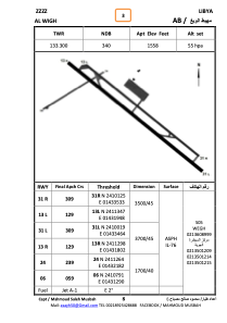
Runways:
| RWY identifier | QFU | Length (ft) | Width (ft) | Surface | LDA (ft) |
| 31L | 310° | 13919 | 213 | ASPH | |
| 13R | 130° | 13919 | 213 | ASPH | |
| 06 | 60° | 5798 | 128 | ASPH | |
| 24 | 240° | 5798 | 128 | ASPH | |
| 31R | 310° | 11784 | 135 | ASPH | |
| 13L | 130° | 11784 | 135 | ASPH |
Airport contact information
Address: Libyan Arab Jamahiriya