


HLUF - Um-Farud
Located in , Libyan Arab Jamahiriya
ICAO - , IATA -
Data provided by AirmateGeneral information
Coordinates: N29°11'0" E18°11'0"
Elevation is 900 feet MSL.
View others Airports in Surt District
Operational data
Special qualification required
Current time UTC:
Current local time:
Weather at : - ( 0 km )
METAR: MUGM 042351h33004KT 10SM FEW025 SCT070 V|rAG> /Q|H#uL T02670239i17 20261 53014 $
Communications frequencies: [VIEW]
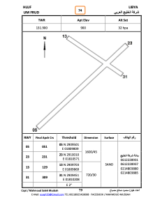
Runways:
| RWY identifier | QFU | Length (ft) | Width (ft) | Surface | LDA (ft) |
| 05 | 0° | 0 | 0 | UNK | |
| 23 | 0° | 0 | 0 | UNK | |
| 13 | 0° | 0 | 0 | UNK | |
| 21 | 0° | 0 | 0 | UNK |
Airport contact information
Address: Libyan Arab Jamahiriya