


HLNM - Hamada Nc-8
Located in , Libyan Arab Jamahiriya
ICAO - , IATA -
Data provided by AirmateGeneral information
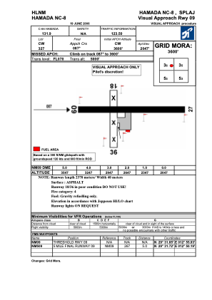
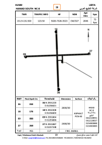
Coordinates: N29°31'52" E12°56'38"
Elevation is 2047 feet MSL.
Magnetic variation is 3° East View others Airports in Al Jabal al Gharbi District
Operational data
Special qualification required
Current time UTC:
Current local time:
Weather at : - ( 0 km )
METAR: PAAK 280740Z AUTO 08013KT 10SM SCT014 BKN020 OVC075 03/02 A2995 RMK AO2
Communications frequencies: [VIEW]
Runways:
| RWY identifier | QFU | Length (ft) | Width (ft) | Surface | LDA (ft) |
| 09 | 89° | 7727 | 106 | ASPH | |
| 27 | 269° | 7727 | 106 | ASPH |
Airport contact information
Address: Libyan Arab Jamahiriya