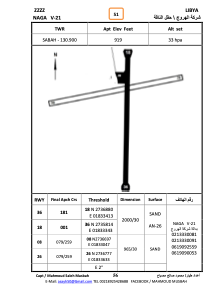


HLNGA - NAGA V-21
Located in , Libyan Arab Jamahiriya
ICAO - , IATA -
Data provided by AirmateGeneral information
Coordinates: N27°36'46" E18°33'38"
Elevation is 919 feet MSL.
Operational data
Special qualification required
Current time UTC:
Current local time:
Weather at : - ( 0 km )
METAR: KAFP 191532Z AUTO 05004KT 10SM BKN012 OVC032 19/16 A2999 RMK AO2 T01850159
Communications frequencies: [VIEW]
Runways:
| RWY identifier | QFU | Length (ft) | Width (ft) | Surface | LDA (ft) |
| 18 | 184° | 6290 | 101 | SAND | |
| 36 | 4° | 6290 | 101 | SAND | |
| 08 | 82° | 3063 | 76 | SAND | |
| 26 | 262° | 3063 | 76 | SAND |
Airport contact information
Address: Libyan Arab Jamahiriya