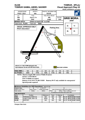


HLGN - Gamal Abdel Nasser Airport
Located in Tobruk, Libyan Arab Jamahiriya
ICAO - HLGN, IATA - TOB
Data provided by AirmateGeneral information
Coordinates: N31°51'40" E23°54'25"
Elevation is 519 feet MSL.
View others Airports in Al Butnan District
Operational data
Special qualification required
Current time UTC:
Current local time:
Weather at : - ( 0 km )
METAR: OERK 011621Z 28011KT 7000 TSRA FEW030CB BKN040 18/15 Q1012
Communications frequencies: [VIEW]
Runways:
Airport contact information
Address: Tobruk Libyan Arab Jamahiriya