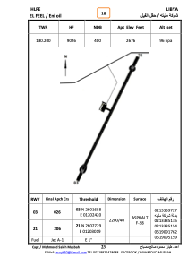


HLFE - El Feel
Located in , Libyan Arab Jamahiriya
ICAO - , IATA -
Data provided by AirmateGeneral information
Coordinates: N26°2'18" E12°2'46"
Elevation is 2674 feet MSL.
Magnetic variation is 2° East View others Airports in Wadi Al Hayaa District
Operational data
Special qualification required
Current time UTC:
Current local time:
Weather at : - ( 0 km )
METAR: PAAK 022103Z AUTO 11018KT 1 1/4SM -RA BR OVC005 05/05 A2936 RMK AO2 CIG 003V008 P0000
Communications frequencies: [VIEW]
Runways:
| RWY identifier | QFU | Length (ft) | Width (ft) | Surface | LDA (ft) |
| 03 | 27° | 7588 | 126 | ASPH | |
| 21 | 207° | 7588 | 126 | ASPH |
Airport contact information
Address: Libyan Arab Jamahiriya