


HLBS - Booster
Located in , Libyan Arab Jamahiriya
ICAO - , IATA -
Data provided by AirmateGeneral information
Coordinates: N29°52'43" E23°20'55"
Elevation is 151 feet MSL.
Magnetic variation is 4° East View others Airports in Al Butnan District
Operational data
Special qualification required
Current time UTC:
Current local time:
Weather at : - ( 0 km )
METAR: YHID 011528Z AUTO 13011KT 5000 -RA SCT007 BKN013 OVC019 27/25 Q1008
Communications frequencies: [VIEW]
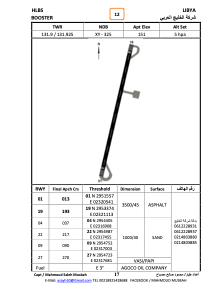
Runways:
| RWY identifier | QFU | Length (ft) | Width (ft) | Surface | LDA (ft) |
| 04 | 0° | 3281 | 131 | SAND | |
| 22 | 0° | 3281 | 131 | SAND | |
| 09 | 0° | 3281 | 131 | SAND | |
| 27 | 0° | 3281 | 131 | SAND | |
| 01 | 15° | 11520 | 180 | ASPH | |
| 19 | 195° | 11520 | 180 | ASPH |
Airport contact information
Address: Libyan Arab Jamahiriya