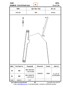


HLBR - Mabruk
Located in , Libyan Arab Jamahiriya
ICAO - , IATA -
Data provided by AirmateGeneral information
Coordinates: N29°51'34" E17°15'17"
Elevation is 800 feet MSL.
Magnetic variation is 3° East View others Airports in Surt District
Operational data
Special qualification required
Current time UTC:
Current local time:
Weather at : - ( 0 km )
METAR: KW96 042135Z AUTO 06005KT 2 1/2SM OVC005 15/14 A3016 RMK AO1 T01480142
Communications frequencies: [VIEW]
Runways:
| RWY identifier | QFU | Length (ft) | Width (ft) | Surface | LDA (ft) |
| 01 | 9° | 7457 | 254 | SAND | |
| 19 | 189° | 7457 | 254 | SAND |
Airport contact information
Address: Libyan Arab Jamahiriya