


HLAM - Amal V12
Located in , Libyan Arab Jamahiriya
ICAO - HLAM, IATA -
Data provided by AirmateGeneral information
Coordinates: N29°28'43" E21°7'27"
Elevation is 144 feet MSL.
Magnetic variation is 4° East View others Airports in Al Wahat District
Operational data
Special qualification required
Current time UTC:
Current local time:
Weather at : - ( 0 km )
METAR: PAKU 081748Z 28006KT 10SM R24/P6000FT OVC008 M06/M07 A2985
Communications frequencies: [VIEW]
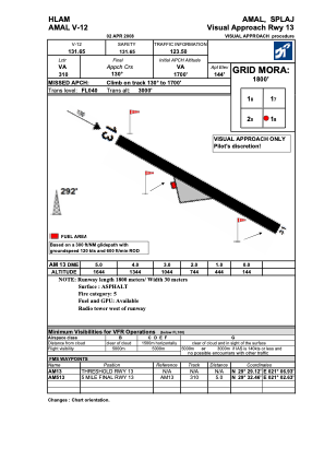
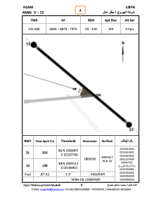
Runways:
| RWY identifier | QFU | Length (ft) | Width (ft) | Surface | LDA (ft) |
| 13 | 132° | 5704 | 95 | ASPH | |
| 31 | 312° | 5704 | 95 | ASPH |
Airport contact information
Address: Libyan Arab Jamahiriya