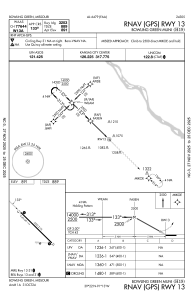


H19 - Bowling Green Muni
Located in Bowling Green, United States
ICAO - H19, IATA -
Data provided by AirmateGeneral information
Coordinates: N39°22'15" W91°13'13"
Elevation is 891 feet MSL.
Magnetic variation is 01° East View others Airports in Missouri
Operational data
Special qualification required
Current time UTC:
Current local time:
Weather at : KHAE - Hannibal Rgnl ( 44 km )
METAR: KHAE 071035Z AUTO 23004KT 10SM CLR 16/15 A2952 RMK AO2 P0001 LTG DSNT NE AND SE
Communications frequencies: [VIEW]
Runways:
| RWY identifier | QFU | Length (ft) | Width (ft) | Surface | LDA (ft) |
| 13 | 134° | 3203 | 75 | CONC | |
| 31 | 314° | 3203 | 75 | CONC |
Airport contact information
Address: Bowling Green United States