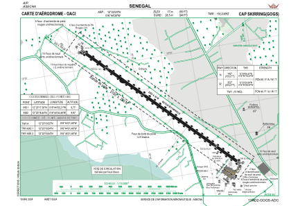


GOGS - Aeroport International De Cap Skirring
Located in Cap Skirring, Senegal
ICAO - GOGS, IATA - CSK
Data provided by AirmateGeneral information
Coordinates: N12°23'20" W16°44'30"
Elevation is 56 feet MSL.
Magnetic variation is -7° East View others Airports in Ziguinchor
Operational data
Special qualification required
Current time UTC:
Current local time:
Weather
METAR: GOGS 272100Z 34004KT CAVOK 26/20 Q1007
TAF: TAF GOGS 271700Z 2718/2818 32010KT 8000 NSC
Communications frequencies: [VIEW]
Runways:
| RWY identifier | QFU | Length (ft) | Width (ft) | Surface | LDA (ft) |
| 14 | 136° | 6562 | 98 | CONC | 6562 |
| 32 | 316° | 6562 | 98 | CONC | 6562 |
Airport contact information
Address: Cap Skirring Senegal