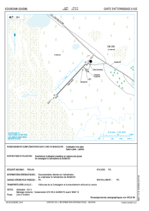


GAGM - Goundam
Located in , Mali
ICAO - GAGM, IATA - GUD
Data provided by AirmateGeneral information
Coordinates: N16°21'0" W3°36'0"
Elevation is 866 feet MSL.
View others Airports in Tombouctou
Operational data
Special qualification required
Current time UTC:
Current local time:
Weather at : GATB - Tombouctou ( 77 km )
METAR: GATB 011200Z 05010KT 010V090 8000 NSC 35/M08 Q1011
Communications frequencies: [VIEW]
Runways:
| RWY identifier | QFU | Length (ft) | Width (ft) | Surface | LDA (ft) |
| 05 | 0° | 4921 | 98 | UNK | |
| 23 | 0° | 4921 | 98 | UNK |
Airport contact information
Address: Mali