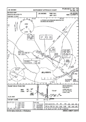
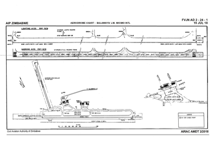


FVJN - Bulawayo/J.M. Nkomo
Located in Bulawayo, Zimbabwe
ICAO - , IATA - BUQ
Data provided by AirmateGeneral information
Coordinates: S20°1'6" E28°37'29"
Elevation is 4366 feet MSL.
View others Airports in Bulawayo
Operational data
Special qualification required
Current time UTC:
Current local time:
Weather
METAR: FVJN 281000Z 14011KT 9999 BKN030 17/10 Q1029 NOSIG
TAF: TAF FVJN 281000Z 2812/2910 12012KT 9999 SCT040 BECMG 2816/2818 CAVOK PROB30 TEMPO 2904/2906 BKN015 BECMG 2908/2910 CAVOK
Communications frequencies: [VIEW]
Runways:
| RWY identifier | QFU | Length (ft) | Width (ft) | Surface | LDA (ft) |
| 02 | 7° | 4419 | 98 | UNK | |
| 20 | 187° | 4419 | 98 | UNK | |
| 13 | 117° | 8491 | 148 | UNK | |
| 31 | 297° | 8491 | 148 | UNK |
Airport contact information
Address: Bulawayo Zimbabwe