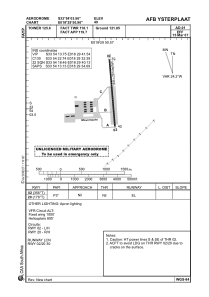


FAYP - Afb Ysterplaat (Mil - Unlicensed)
Located in Ysterplaat, South Africa
ICAO - FAYP, IATA -
Data provided by AirmateGeneral information
Coordinates: S33°54'4" E18°29'51"
Elevation is 49 feet MSL.
Magnetic variation is -26° East View others Airports in Western Cape
Operational data
Special qualification required
Current time UTC:
Current local time:
Weather at : - ( 0 km )
METAR: CYYW 291937Z AUTO 09010G15KT 1 1/2SM -FZRA BR BKN009 BKN017 OVC027 M01/M02 A2994 RMK ICE PRESFR PCPN 1.0MM PAST HR SLP161
Communications frequencies: [VIEW]
Runways:
| RWY identifier | QFU | Length (ft) | Width (ft) | Surface | LDA (ft) |
| 02 | 356° | 5186 | 95 | ASPH | 5200 |
| 20 | 176° | 5186 | 95 | ASPH | 5200 |
Airport contact information
Address: Ysterplaat South Africa