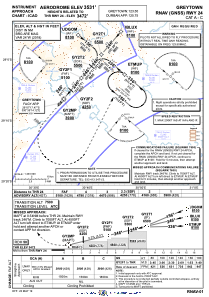
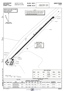


FAGY - Greytown
Located in Greytown, South Africa
ICAO - FAGY, IATA -
Data provided by AirmateGeneral information
Coordinates: S29°7'17" E30°35'14"
Elevation is 3531 feet MSL.
Magnetic variation is -24° East View others Airports in Kwazulu-Natal
Operational data
Special qualification required
Current time UTC:
Current local time:
Weather at : FAPM - Pietermaritzburg ( 61 km )
TAF: TAF FAPM 050600Z 0507/0518 VRB03KT CAVOK TX29/0512Z TN17/0518Z BECMG 0510/0512 05006KT
Communications frequencies: [VIEW]
Runways:
| RWY identifier | QFU | Length (ft) | Width (ft) | Surface | LDA (ft) |
| 06 | 41° | 4784 | 41 | ASPH | 4797 |
| 24 | 221° | 4784 | 41 | ASPH | 4797 |
Airport contact information
Address: Greytown South Africa