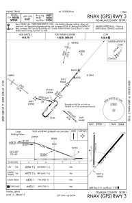
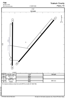


F98 - Yoakum County
Located in Plains, United States
ICAO - F98, IATA -
Data provided by AirmateGeneral information
Coordinates: N33°13'2" W102°49'48"
Elevation is 3705 feet MSL.
Magnetic variation is 07° East View others Airports in Texas
Operational data
Special qualification required
Current time UTC:
Current local time:
Weather at : KGNC - Gaines County ( 62 km )
METAR: KGNC 012255Z AUTO 12014G22KT 10SM BKN110 25/10 A2971 RMK AO2 T02450101
Communications frequencies: [VIEW]
Runways:
| RWY identifier | QFU | Length (ft) | Width (ft) | Surface | LDA (ft) |
| 03 | 40° | 5001 | 75 | ASPH | |
| 21 | 220° | 5001 | 75 | ASPH | |
| 17 | 180° | 3924 | 60 | ASPH | |
| 35 | 360° | 3924 | 60 | ASPH |
Airport contact information
Address: Plains United States