


F21 - Memphis Muni
Located in Memphis, United States
ICAO - F21, IATA -
Data provided by AirmateGeneral information
Coordinates: N34°44'23" W100°31'47"
Elevation is 2102 feet MSL.
Magnetic variation is 08° East View others Airports in Texas
Operational data
Special qualification required
Current time UTC:
Current local time:
Weather at : KCDS - Childress Muni ( 41 km )
METAR: KCDS 011353Z AUTO 16012G19KT 9SM BKN007 21/20 A2981 RMK AO2 SLP068 T02110200
TAF: KCDS 011359Z 0114/0212 16015KT P6SM BKN007 FM011600 16015KT P6SM SCT035 FM012000 16020G30KT P6SM SCT050
Communications frequencies: [VIEW]
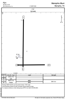
Runways:
| RWY identifier | QFU | Length (ft) | Width (ft) | Surface | LDA (ft) |
| 08 | 90° | 2750 | 70 | GRASS | |
| 26 | 270° | 2750 | 70 | GRASS | |
| 17 | 181° | 4670 | 75 | ASPH | |
| 35 | 1° | 4670 | 75 | ASPH |
Airport contact information
Address: Memphis United States