


ENSA - Svea
Located in Sveagruva, Norway
ICAO - ENSA, IATA -
Data provided by AirmateGeneral information
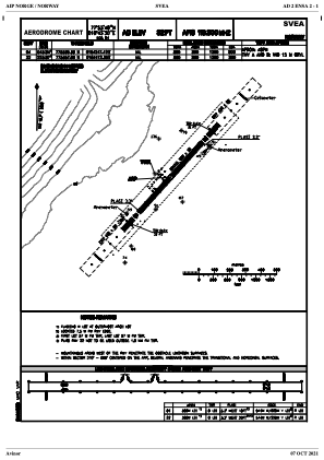
Coordinates: N77°53'49" E16°43'30"
Elevation is 32 feet MSL.
Magnetic variation is 10.7° East View others Airports in Svalbard
Operational data
Special qualification required
Current time UTC:
Current local time:
Weather at : ENSB - Longyear ( 48 km )
METAR: ENSB 291920Z 23011KT 9999 VCSH FEW006 SCT014 BKN020 00/M03 Q1024 RMK WIND 1400FT 24014KT
TAF: TAF ENSB 291700Z 2918/3018 24009KT 9999 FEW015 BKN035 TEMPO 2918/2924 4000 -SNRA BKN008 PROB30 TEMPO 2923/3011 BKN004 BECMG 3009/3012 24019KT
Communications frequencies: [VIEW]
Runways:
Airport contact information
Address: Sveagruva Norway