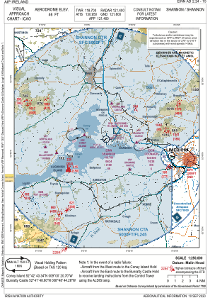
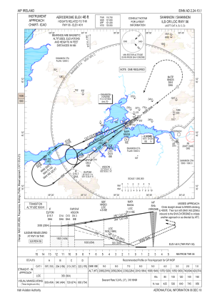
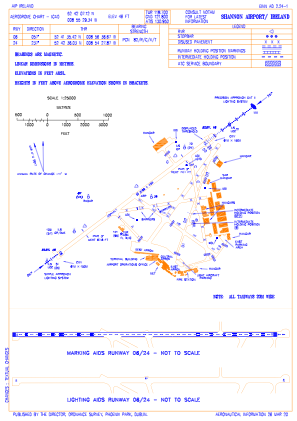


EINN - Shannon
Located in Limerick, Ireland
ICAO - EINN, IATA - SNN
Data provided by AirmateGeneral information
Coordinates: N52°42'7" W8°55'29"
Elevation is 46 feet MSL.
Magnetic variation is -4° East View others Airports in County Clare
Operational data
Special qualification required
Current time UTC:
Current local time:
Weather
METAR: EINN 291630Z 23009KT 9999 FEW030 BKN140 13/05 Q1002 NOSIG
TAF: TAF EINN 291100Z 2912/3012 24014KT 9999 SCT018 BKN035 TEMPO 2912/2920 -SHRA FEW018CB TEMPO 2912/2916 25016G26KT BECMG 2916/2918 20010KT BECMG 2919/2921 11006KT TEMPO 3000/3006 3000 SHRA BKN010 SCT018CB PROB40 TEMPO 3006/3010 -SHRA BKN010 FEW018CB BECMG 3010/3012 19010KT TEMPO 3010/3012 4000 SHRA SCT018CB
Communications frequencies: [VIEW]
Runways:
| RWY identifier | QFU | Length (ft) | Width (ft) | Surface | LDA (ft) |
| 06 | 52° | 10495 | 148 | ASPH | 10495 |
| 24 | 232° | 10495 | 148 | ASPH | 10036 |
Airport contact information
Address: Limerick Ireland
