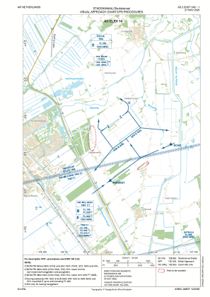
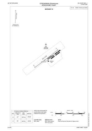


EHST - Stadskanaal
Located in Stadskanaal, Netherlands
ICAO - EHST, IATA -
Data provided by AirmateGeneral information
Coordinates: N52°59'55" E7°1'22"
Elevation is 14 feet MSL.
Magnetic variation is 2.2238° East View others Airports in Groningen
Operational data
Special qualification required
Current time UTC:
Current local time:
Weather at : EHGG - Groningen/Eelde ( 33 km )
METAR: EHGG 012355Z AUTO 06011KT 9999 NSC 16/12 Q1003
TAF: TAF EHGG 012306Z 0200/0306 07009KT CAVOK BECMG 0207/0210 10011KT BECMG 0217/0220 07006KT PROB30 TEMPO 0218/0223 4000 SHRA TSRA FEW050CB BECMG 0300/0303 6000 BKN006 PROB30 TEMPO 0301/0306 3000 BR BKN003
Communications frequencies: [VIEW]
Runways:
| RWY identifier | QFU | Length (ft) | Width (ft) | Surface | LDA (ft) |
| 06 | 60° | 1640 | 98 | GRASS | |
| 24 | 240° | 1640 | 98 | GRASS |
Airport contact information
Address: Stadskanaal Netherlands
