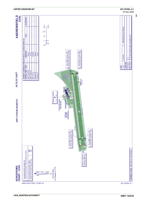


EGSL - Andrewsfield
Located in Braintree, United Kingdom
ICAO - EGSL, IATA -
Data provided by AirmateGeneral information
Coordinates: N51°53'42" E0°26'57"
Elevation is 286 feet MSL.
View others Airports in England
Operational data
Special qualification required
Current time UTC:
Current local time:
Weather at : EGSS - London Stansted ( 15 km )
TAF: TAF EGSS 290457Z 2906/3012 18011KT 7000 FEW038 BECMG 2906/2908 9999 TEMPO 2908/2918 19017G28KT BECMG 2923/3002 12005KT PROB30 3002/3007 8000
Communications frequencies: [VIEW]
Runways:
| RWY identifier | QFU | Length (ft) | Width (ft) | Surface | LDA (ft) |
| 09L | 85° | 2621 | 59 | Grass | |
| 27R | 265° | 2621 | 59 | Grass | |
| 09R | 85° | 2621 | 59 | Grass | |
| 27L | 265° | 2621 | 59 | Grass |
Airport contact information
Address: Braintree United Kingdom