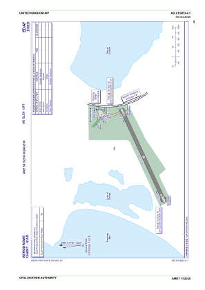


EGED - Eday
Located in Eday Island, United Kingdom
ICAO - EGED, IATA - EOI
Data provided by AirmateGeneral information
Coordinates: N59°11'25" W2°46'21"
Elevation is 13 feet MSL.
View others Airports in Scotland
Operational data
Special qualification required
Current time UTC:
Current local time:
Weather at : EGPA - Kirkwall ( 27 km )
METAR: EGPA 302050Z AUTO 13013KT 9999 NCD 09/07 Q1012
TAF: TAF EGPA 301955Z 3021/0106 13012KT 9999 FEW010 BECMG 0100/0103 BKN006 TEMPO 0103/0106 6000 BKN004
Communications frequencies: [VIEW]
Runways:
| RWY identifier | QFU | Length (ft) | Width (ft) | Surface | LDA (ft) |
| 07 | 64° | 1729 | 59 | Graded Hardcore | |
| 25 | 244° | 1729 | 59 | Graded Hardcore |
Airport contact information
Address: Eday Island United Kingdom