


EGBK - Northampton/Sywell
Located in Northampton, United Kingdom
ICAO - EGBK, IATA - ORM
Data provided by AirmateGeneral information
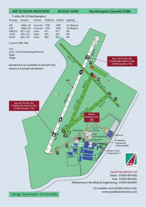
Coordinates: N52°18'22" W0°47'32"
Elevation is 424 feet MSL.
View others Airports in England
Operational data
Special qualification required
Current time UTC:
Current local time:
Weather at : EGTC - Cranfield ( 29 km )
TAF: TAF EGTC 281357Z 2815/2817 22009KT 9999 SCT008 BKN020 TEMPO 2815/2816 8000 -RA BKN010 PROB30 TEMPO 2816/2817 7000 SHRA
Communications frequencies: [VIEW]
Runways:
| RWY identifier | QFU | Length (ft) | Width (ft) | Surface | LDA (ft) |
| 03R | 25° | 2201 | 98 | Grass | |
| 21L | 205° | 2201 | 98 | Grass | |
| 05 | 52° | 1978 | 92 | Grass | |
| 23 | 232° | 1978 | 92 | Grass | |
| 03L | 25° | 4127 | 98 | Concrete | |
| 21R | 205° | 4127 | 98 | Concrete | |
| 14 | 134° | 2628 | 82 | UNK | |
| 32 | 314° | 2628 | 82 | UNK |
Airport contact information
Address: Northampton United Kingdom
Other aviation service providers
Flight schools

Sywell Aviation Limited T/A Brooklands Flying Club
Sywell Aviation Limited T/A Brooklands Flying Club
info@2exceltraining.com+44 01604496600