


EGAD - Newtownards
Located in Belfast, United Kingdom
ICAO - EGAD, IATA -
Data provided by AirmateGeneral information
Coordinates: N54°34'52" W5°41'31"
Elevation is 9 feet MSL.
View others Airports in Northern Ireland
Operational data
Special qualification required
Current time UTC:
Current local time:
Weather at : EGAC - Belfast/City ( 12 km )
METAR: EGAC 050620Z AUTO 16003KT 9000 FEW011 OVC036 11/11 Q1007
TAF: TAF EGAC 050459Z 0506/0515 VRB02KT 9999 BKN040 TEMPO 0506/0509 BKN010 PROB30 TEMPO 0506/0509 4000 -RADZ BKN005 PROB30 TEMPO 0509/0515 6000 SHRA BKN014
Communications frequencies: [VIEW]
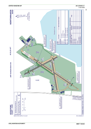
Runways:
| RWY identifier | QFU | Length (ft) | Width (ft) | Surface | LDA (ft) |
| 15 | 150° | 2100 | 59 | Asphalt | |
| 33 | 330° | 2100 | 59 | Asphalt | |
| 03 | 31° | 2595 | 59 | UNK | |
| 21 | 211° | 2595 | 59 | UNK | |
| 08 | 77° | 1857 | 59 | Asphalt | |
| 26 | 257° | 1857 | 59 | Asphalt |
Airport contact information
Address: Belfast United Kingdom
Other aviation service providers
Flight schools

Jonathan Beckett T/A Jrf Aviation
Jonathan Beckett T/A Jrf Aviation
jonny@jrfaviation.com+44 07793712191