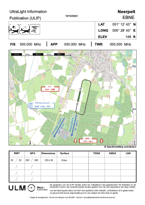


EBNE - Neerpelt
Located in Neerpelt, Belgium
ICAO - EBNE, IATA -
Data provided by AirmateGeneral information
Coordinates: N51°12'43" E5°28'43"
Elevation is 140 feet MSL.
Magnetic variation is 2° East View others Airports in Limburg
Operational data
Special qualification required
Current time UTC:
Current local time:
Weather at : EBBL - Kleine-Brogel ( 5 km )
METAR: EBBL 042325Z AUTO VRB01KT 0200 FG FEW010/// SCT021/// ///// Q1008 RED
Communications frequencies: [VIEW]
Runways:
Airport contact information
Address: Neerpelt Belgium