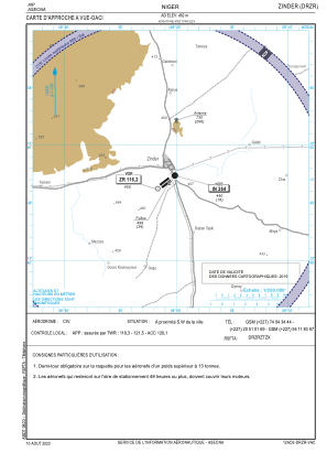
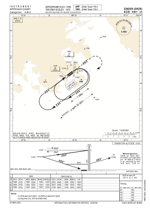


DRZR - Zinder
Located in Zinder, Niger
ICAO - DRZR, IATA - ZND
Data provided by AirmateGeneral information
Coordinates: N13°47'2" E8°59'25"
Elevation is 1506 feet MSL.
View others Airports in Zinder Region
Operational data
Special qualification required
Current time UTC:
Current local time:
Weather
METAR: DRZR 031000Z 35014KT 330V040 CAVOK 39/16 Q1012
TAF: TAF DRZR 030500Z 0306/0406 28010KT 8000 NSC TEMPO 0306/0309 2500 DU BECMG 0310/0312 12010KT
Communications frequencies: [VIEW]
Runways:
| RWY identifier | QFU | Length (ft) | Width (ft) | Surface | LDA (ft) |
| 05 | 53° | 6890 | 98 | ASP | |
| 23 | 233° | 6890 | 98 | ASP |
Airport contact information
Address: Zinder Niger