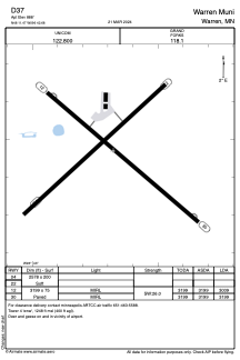


D37 - Warren Muni
Located in Warren, United States
ICAO - D37, IATA -
Data provided by AirmateGeneral information
Coordinates: N48°11'28" W96°42'41"
Elevation is 888 feet MSL.
Magnetic variation is 05° East View others Airports in Minnesota
Operational data
Special qualification required
Current time UTC:
Current local time:
Weather at : KCKN - Crookston Muni/Kirkwood Fld ( 39 km )
METAR: KCKN 061155Z AUTO 12012KT 10SM CLR 12/03 A2984 RMK AO2
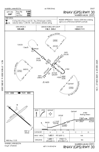
Communications frequencies: [VIEW]
Runways:
| RWY identifier | QFU | Length (ft) | Width (ft) | Surface | LDA (ft) |
| 04 | 48° | 2578 | 200 | GRASS | |
| 22 | 228° | 2578 | 200 | GRASS | |
| 12 | 130° | 3199 | 75 | ASPH | 3009 |
| 30 | 310° | 3199 | 75 | ASPH | 3199 |
Airport contact information
Address: Warren United States