


CYZT - Port Hardy
Located in Port Hardy, Canada
ICAO - CYZT, IATA - YZT
Data provided by AirmateGeneral information
Coordinates: N50°40'50" W127°22'0"
Elevation is 71 feet MSL.
Magnetic variation is 20° East View others Airports in British Columbia
Operational data
Special qualification required
Current time UTC:
Current local time:
Weather
METAR: CYZT 282248Z 28010KT 15SM -SHRA BKN034 BKN080 BKN180 07/04 A2998 RMK CU5AC1CI1 SLP153
TAF: TAF CYZT 281841Z 2819/2907 22007KT P6SM SCT020 BKN070 TEMPO 2819/2907 P6SM -SHRA BKN020 OVC050 RMK NXT FCST BY 290100Z
Communications frequencies: [VIEW]
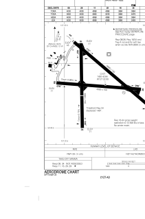
Runways:
| RWY identifier | QFU | Length (ft) | Width (ft) | Surface | LDA (ft) |
| 08 | 94° | 4000 | 150 | ASPH | 4000 |
| 26 | 274° | 4000 | 150 | ASPH | 4000 |
| 11 | 130° | 4999 | 150 | ASPH | 4999 |
| 29 | 310° | 4999 | 150 | ASPH | 4999 |
| 16 | 180° | 3984 | 150 | ASPH | 3984 |
| 34 | 360° | 3984 | 150 | ASPH | 2493 |
| 07 | 0° | 4000 | 150 | ASPH | |
| 25 | 0° | 4000 | 150 | ASPH |
Airport contact information
Address: Port Hardy Canada