


CYYY - Mont-Joli
Located in , Canada
ICAO - CYYY, IATA - YYY
Data provided by AirmateGeneral information
Coordinates: N48°36'32" W68°12'29"
Elevation is 172 feet MSL.
Magnetic variation is -18.4° East View others Airports in Quebec
Operational data
Special qualification required
Current time UTC:
Current local time:
Weather
METAR: CYYY 021900Z 06020G30KT 30SM FEW004 SCT060 SCT100 BKN200 07/04 A3009 RMK SF1SC2AC1CI1 SLP194
TAF: TAF CYYY 021942Z 0220/0308 05018G28KT P6SM BKN050 TEMPO 0220/0224 SCT050 FM030000 05015G25KT P6SM SCT020 BKN040 TEMPO 0300/0308 BKN020 BKN040 BECMG 0301/0303 06012KT RMK NXT FCST BY 030200Z
Communications frequencies: [VIEW]
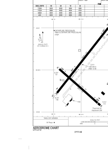
Runways:
| RWY identifier | QFU | Length (ft) | Width (ft) | Surface | LDA (ft) |
| 06 | 38° | 6000 | 150 | ASPH | 6000 |
| 24 | 218° | 6000 | 150 | ASPH | 6000 |
| 15 | 132° | 3954 | 150 | ASPH | 3954 |
| 33 | 312° | 3954 | 150 | ASPH | 3724 |
Airport contact information
Address: Canada