


CYTB - Tillsonburg
Located in , Canada
ICAO - , IATA -
Data provided by AirmateGeneral information
Coordinates: N42°55'35" W80°44'49"
Elevation is 893 feet MSL.
Magnetic variation is -9° East View others Airports in Ontario
Operational data
Special qualification required
Current time UTC:
Current local time:
Weather at : CYXU - London ( 35 km )
METAR: CYXU 281641Z 20011KT 10SM SCT007 OVC080 18/17 A3005 RMK SF6AC2 CIG RAG SLP178 DENSITY ALT 1400FT
TAF: TAF AMD CYXU 281618Z 2816/2912 23010G20KT P6SM -SHRA SCT008 OVC030 TEMPO 2816/2820 5SM -SHRA BR BKN007 OVC030 FM282000 24010KT P6SM SCT020 BKN030 TEMPO 2820/2823 P6SM -SHRA BKN020 OVC030 BECMG 2821/2823 07005KT FM290300 12008KT 6SM BR FEW005 BKN060 PROB30 2903/2906 1SM BR BKN005 FM290600 11012KT 1SM BR OVC005 RMK NXT FCST BY 281800Z
Communications frequencies: [VIEW]
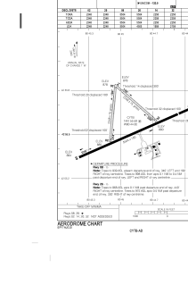
Runways:
| RWY identifier | QFU | Length (ft) | Width (ft) | Surface | LDA (ft) |
| 08 | 66° | 5502 | 100 | ASPH | 5502 |
| 26 | 246° | 5502 | 100 | ASPH | 4502 |
| 02 | 5° | 2348 | 75 | GRASS | 2248 |
| 20 | 185° | 2348 | 75 | GRASS | 2248 |
| 14 | 131° | 2258 | 75 | GRASS | 1958 |
| 32 | 311° | 2258 | 75 | GRASS | 2158 |
Airport contact information
Address: Canada
