


CYRL - Red Lake
Located in , Canada
ICAO - CYRL, IATA - YRL
Data provided by AirmateGeneral information
Coordinates: N51°4'2" W93°47'35"
Elevation is 1266 feet MSL.
Magnetic variation is -0.0667° East View others Airports in Ontario
Operational data
Special qualification required
Current time UTC:
Current local time:
Weather
METAR: CYRL 272100Z 02012G18KT 12SM -SHSN FEW008 BKN011 OVC023 01/M02 A2998 RMK SF1SC6SC1 CVCTV CLD EMBD SLP171
TAF: TAF CYRL 271940Z 2720/2802 36010G20KT 2SM -SHSNRA BR BKN012 OVC025 TEMPO 2720/2721 P6SM -SHSNRA SCT012 OVC025 FM272100 03010G20KT P6SM OVC020 TEMPO 2721/2802 OVC025 BECMG 2722/2724 03010KT RMK NXT FCST BY 281100Z
Communications frequencies: [VIEW]
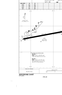
Runways:
| RWY identifier | QFU | Length (ft) | Width (ft) | Surface | LDA (ft) |
| 08 | 79° | 5001 | 150 | ASPH | 5001 |
| 26 | 260° | 5001 | 150 | ASPH | 5001 |
Airport contact information
Address: Canada