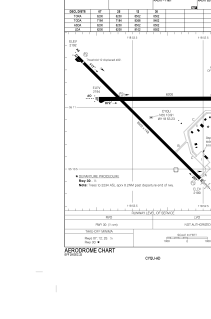


CYQU - Grande Prairie
Located in , Canada
ICAO - CYQU, IATA - YQU
Data provided by AirmateGeneral information
Coordinates: N55°10'55" W118°53'14"
Elevation is 2196 feet MSL.
Magnetic variation is 17.6625° East View others Airports in Alberta
Operational data
Special qualification required
Current time UTC:
Current local time:
Weather
METAR: CYQU 020200Z VRB02KT 25SM SCT025 BKN065 BKN220 07/04 A3012 RMK SC4SC1CI1 SLP226
TAF: TAF CYQU 020040Z 0201/0213 VRB03KT P6SM SCT015 BKN060 TEMPO 0201/0202 P6SM -SHRA BKN015 FM020200 VRB03KT P6SM SCT025 BKN060 FM020900 29006KT P6SM SCT025 BKN060 TEMPO 0209/0213 P6SM -SHRA BKN020 OVC060 RMK NXT FCST BY 020700Z
Communications frequencies: [VIEW]
Runways:
| RWY identifier | QFU | Length (ft) | Width (ft) | Surface | LDA (ft) |
| 07 | 90° | 6200 | 200 | ASPH | 6200 |
| 25 | 270° | 6200 | 200 | ASPH | 6200 |
| 12 | 135° | 8502 | 150 | ASPH | 8102 |
| 30 | 315° | 8502 | 150 | ASPH | 8502 |
Airport contact information
Address: Canada
