


CYQS - St Thomas Muni
Located in St Thomas, Canada
ICAO - CYQS, IATA - YQS
Data provided by AirmateGeneral information
Coordinates: N42°46'12" W81°6'39"
Elevation is 779 feet MSL.
Magnetic variation is -09° East View others Airports in Ontario
Operational data
Special qualification required
Current time UTC:
Current local time:
Weather at : CYXU - London ( 29 km )
METAR: CYXU 272200Z 20017G23KT 15SM FEW042 SCT250 22/15 A2997 RMK SC2CI2 SLP152 DENSITY ALT 2000FT
TAF: TAF CYXU 271740Z 2718/2818 16015G25KT P6SM SCT040 BKN160 TEMPO 2718/2719 P6SM -SHRA OVC040 FM271900 19015G25KT P6SM BKN050 BECMG 2722/2724 20010KT FM281100 24008KT P6SM -SHRA OVC040 FM281600 23010G20KT P6SM BKN050 RMK NXT FCST BY 280000Z
Communications frequencies: [VIEW]
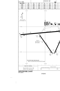
Runways:
| RWY identifier | QFU | Length (ft) | Width (ft) | Surface | LDA (ft) |
| 09 | 85° | 5050 | 100 | ASPH | 5013 |
| 27 | 265° | 5050 | 100 | ASPH | 5013 |
| 03 | 25° | 2640 | 75 | ASPH | 2607 |
| 21 | 205° | 2640 | 75 | ASPH | 2607 |
| 15 | 145° | 2640 | 75 | ASPH | 2610 |
| 33 | 325° | 2640 | 75 | ASPH | 2610 |
Airport contact information
Address: St Thomas Canada
