


CYLL - Lloydminster
Located in , Canada
ICAO - CYLL, IATA - YLL
Data provided by AirmateGeneral information
Coordinates: N53°18'38" W110°4'27"
Elevation is 2194 feet MSL.
Magnetic variation is 12.9° East View others Airports in Alberta
Operational data
Special qualification required
Current time UTC:
Current local time:
Weather
TAF: TAF CYLL 012340Z 0200/0212 05012G22KT P6SM -RA OVC030 TEMPO 0200/0204 5SM -SHRA BR BKN020 OVC030 FM020400 02008KT P6SM SCT030 BKN090 TEMPO 0204/0211 P6SM -RA BKN030 FM021100 02012KT P6SM FEW008 OVC080 TEMPO 0211/0212 2SM -SHSNRA BR VV008 RMK NXT FCST BY 020600Z
Communications frequencies: [VIEW]
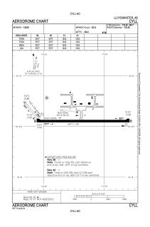
Runways:
| RWY identifier | QFU | Length (ft) | Width (ft) | Surface | LDA (ft) |
| 13 | 139° | 1202 | 100 | GRASS | 1202 |
| 31 | 319° | 1202 | 100 | GRASS | 1202 |
| 08 | 90° | 5577 | 150 | ASPH | 5577 |
| 26 | 270° | 5577 | 150 | ASPH | 5577 |
Airport contact information
Address: Canada
