


CYLD - Chapleau
Located in , Canada
ICAO - CYLD, IATA - YLD
Data provided by AirmateGeneral information
Coordinates: N47°49'13" W83°20'49"
Elevation is 1470 feet MSL.
Magnetic variation is -8.8478° East View others Airports in Ontario
Operational data
Special qualification required
Current time UTC:
Current local time:
Weather
TAF: TAF AMD CYLD 271521Z 2715/2801 17010KT 5SM -SHRA BR BKN007 OVC020 TEMPO 2715/2718 P6SM -SHRA SCT008 OVC020 FM271800 17010G20KT P6SM -SHRA OVC012 TEMPO 2718/2801 4SM -SHRA BR OVC008 PROB30 2718/2801 OVC007 RMK NXT FCST BY 272000Z
Communications frequencies: [VIEW]
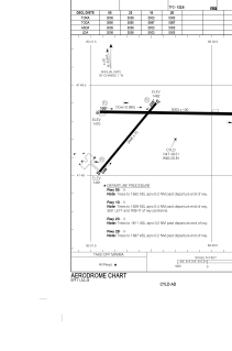
Runways:
| RWY identifier | QFU | Length (ft) | Width (ft) | Surface | LDA (ft) |
| 05 | 39° | 3006 | 75 | ASPH | 3006 |
| 23 | 220° | 3006 | 75 | ASPH | 3006 |
| 10 | 91° | 5003 | 100 | ASPH | 5003 |
| 28 | 271° | 5003 | 100 | ASPH | 5003 |
Airport contact information
Address: Canada