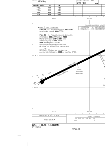


CYGV - Havre St-Pierre
Located in Havre St-Pierre, Canada
ICAO - CYGV, IATA - YGV
Data provided by AirmateGeneral information
Coordinates: N50°16'55" W63°36'40"
Elevation is 125 feet MSL.
Magnetic variation is -18.0969° East View others Airports in Quebec
Operational data
Special qualification required
Current time UTC:
Current local time:
Weather
METAR: CYGV 022300Z AUTO 03013G18KT 9SM BKN042 08/M00 A3019 RMK SLP227
TAF: TAF CYGV 021942Z 0220/0308 03012G22KT P6SM BKN040 FM030000 03012G22KT P6SM SCT020 BKN030 TEMPO 0300/0303 P6SM -SHRA OVC020 FM030300 04012G22KT P6SM -RA SCT015 OVC030 TEMPO 0303/0308 4SM -RA BR SCT008 OVC015 RMK FCST BASED ON AUTO OBS. NXT FCST BY 030200Z
Communications frequencies: [VIEW]
Runways:
| RWY identifier | QFU | Length (ft) | Width (ft) | Surface | LDA (ft) |
| 08 | 63° | 4498 | 100 | ASPH | 4498 |
| 26 | 243° | 4498 | 100 | ASPH | 4498 |
Airport contact information
Address: Havre St-Pierre Canada