


CYGP - Gaspe (Michel-Pouliot)
Located in , Canada
ICAO - CYGP, IATA - YGP
Data provided by AirmateGeneral information
Coordinates: N48°46'30" W64°28'54"
Elevation is 112 feet MSL.
Magnetic variation is -19.2867° East View others Airports in Quebec
Operational data
Special qualification required
Current time UTC:
Current local time:
Weather
TAF: TAF CYGP 021942Z 0220/0308 02008KT P6SM SCT020 BKN030 TEMPO 0220/0305 BKN020 OVC030 FM030500 01006KT P6SM SCT008 OVC015 TEMPO 0305/0308 4SM -DZ BR BKN008 OVC015 PROB30 0305/0308 BKN006 OVC012 RMK NXT FCST BY 030200Z
Communications frequencies: [VIEW]
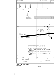
Runways:
| RWY identifier | QFU | Length (ft) | Width (ft) | Surface | LDA (ft) |
| 10 | 84° | 5488 | 150 | ASPH | 5488 |
| 28 | 264° | 5488 | 150 | ASPH | 5488 |
Airport contact information
Address: Canada