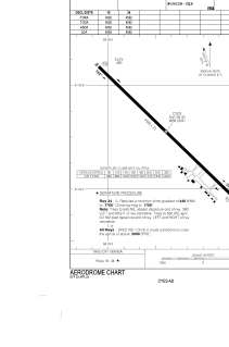


CYES - Edmundston
Located in , Canada
ICAO - CYES, IATA -
Data provided by AirmateGeneral information
Coordinates: N47°29'24" W68°28'54"
Elevation is 498 feet MSL.
Magnetic variation is -17.5833° East View others Airports in New Brunswick
Operational data
Special qualification required
Current time UTC:
Current local time:
Weather at : KFVE - Northern Aroostook Rgnl ( 26 km )
METAR: KFVE 272153Z AUTO 14006KT 10SM CLR 16/M08 A3026 RMK AO2 SLP253 T01561083
TAF: KFVE 271730Z 2718/2818 VRB06KT P6SM FEW200 FM280600 15007KT P6SM BKN160
Communications frequencies: [VIEW]
Runways:
| RWY identifier | QFU | Length (ft) | Width (ft) | Surface | LDA (ft) |
| 16 | 134° | 4562 | 75 | ASPH | 4562 |
| 34 | 314° | 4562 | 75 | ASPH | 4562 |
Airport contact information
Address: Canada