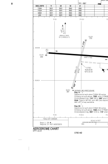


CYDO - Lac-Saint Jean
Located in , Canada
ICAO - CYDO, IATA - YDO
Data provided by AirmateGeneral information
Coordinates: N48°46'36" W72°22'30"
Elevation is 373 feet MSL.
Magnetic variation is -15.8802° East View others Airports in Quebec
Operational data
Special qualification required
Current time UTC:
Current local time:
Weather at : CYRJ - Roberval ( 30 km )
METAR: CYRJ 022300Z 08003KT 050V110 40SM BKN071 BKN220 15/02 A3008 RMK AC6CI1 CI TR SLP194
TAF: TAF CYRJ 021943Z 0220/0302 07007KT P6SM SCT060 BKN120 TEMPO 0220/0302 BKN060 BKN120 RMK NXT FCST BY 031200Z
Communications frequencies: [VIEW]
Runways:
| RWY identifier | QFU | Length (ft) | Width (ft) | Surface | LDA (ft) |
| 11 | 94° | 5001 | 100 | ASPH | 5001 |
| 29 | 274° | 5001 | 100 | ASPH | 5001 |
| 03 | 16° | 3563 | 72 | GRAVE | 3563 |
| 21 | 196° | 3563 | 72 | GRAVE | 3563 |
Airport contact information
Address: Canada
