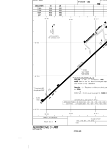


CYCK - Chatham-Kent
Located in , Canada
ICAO - CYCK, IATA - XCM
Data provided by AirmateGeneral information
Coordinates: N42°18'22" W82°4'54"
Elevation is 645 feet MSL.
Magnetic variation is -8.2189° East View others Airports in Ontario
Operational data
Special qualification required
Current time UTC:
Current local time:
Weather
METAR: CYCK 281148Z AUTO 25009KT 9SM BKN100 BKN120 17/16 A3004 RMK SLP173 DENSITY ALT 1000FT
Communications frequencies: [VIEW]
Runways:
| RWY identifier | QFU | Length (ft) | Width (ft) | Surface | LDA (ft) |
| 06 | 47° | 5502 | 75 | ASPH | 5002 |
| 24 | 227° | 5502 | 75 | ASPH | 5002 |
Airport contact information
Address: Canada